Tour of the Alps 2002
Back to Day 2
Day 3: 23 June 2002: la marche de les morts
My journal entry for the day begins, "This may be the dumbest thing
I've ever done." A combination of overestimating one's abilities,
underestimating the difficulty and unexpectedly hot weather can lead
to an "uncomfortable" day out. Such was the case today.
The plan was to ride from Bourg-d'Oisans to Rochetaillee, then to
climb the Col du Glandon/Col de la Croix de Fer, descend to
St.-Jean-de-Maurienne, ride to St.-Michel-de-Maurienne, climb the Col
du Telegraphe, descend to Valloire, climb the Col du Galibier, climb
the Col du Lauteret (readers familiar with the area will immediately
see the flaw in that) and then ride mostly downhill back to
Bourg-d'Oisans. If we had added an ascent up l'Alpe-d'Huez at the
end, we'd have ridden the route of La Marmotte, an annual cyclosportif
event that would be held a couple of weeks later. Fons, one of the
other guests at the gite, had ridden La Marmotte many times and in
fact had ridden the same loop yesterday as preparation for this year's
edition, commenting that the heat made it extra difficult. I put it
down to being his Belgian and unacclimatized to heat. Those who don't
pay attention to history are doomed to repeat it.
 Chuffed with the seeming ease in which l'Alpe-d'Huez and Col du
Sarenne were climbed, I had no doubt of being able to knock off this
little loop and be back in time for supper. Naiviete can easily
become foolishness- after all, I had never ridden a mountain until
yesterday and today we were going to essentially do a Tour de France
stage.
Chuffed with the seeming ease in which l'Alpe-d'Huez and Col du
Sarenne were climbed, I had no doubt of being able to knock off this
little loop and be back in time for supper. Naiviete can easily
become foolishness- after all, I had never ridden a mountain until
yesterday and today we were going to essentially do a Tour de France
stage.
We rolled out of Bourg-d'Oisans on the N91, effortlessly spinning
down the false flat toward Rochetaillee. We turned right on the D526,
following the signs to the Col de la
Croix de Fer. The road proceeded through a lovely valley with
quaint towns along l'Eau d'Olle. We stopped at a patisserie in
Allemond and I put a brioche aux abricots in my pocket for
later. The valley was relatively flat with several switchbacks to get
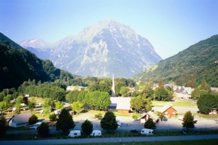
over the Barrage du Verney for the EDF power station. Looking
back from partway up the dam, I saw Allemond's church steeple which
appeared to have been carved from a single mass of stone- quite
beautiful. We also saw a group of cyclists following behind us.
The road began to gently climb after this, winding through a lovely
shaded valley. The grade gadually steepened but remained quite
comfortable to ride. We rode through an occasional town and in le
Rivier d'Allemont stopped at the town water spigot to refill bottles-
with eau potable that would probably cost a couple of bucks per
bidon in a U.S. supermarket. 
A couple of kilometers later, we were confronted with a twisty 12%
grade going down, giving up several hundred meters of the altitude
we'd gained. At the bottom was a bridge over a stream with a sign
announcing passage submersible, which for some reason I found
rather humorous. On the other side the road was quite steep going
back up; I experimented with switching back and forth over the road
and found that it was possible to climb quite quickly that way. I
even passed Keith doing this. After a couple of kilometers the grade
lessened and it was back to "normal" climbing at 6-8 mph. The geology
here in le Defile de Maupas was noticeably different, as was
the vegetation, from the earlier part of the climb. There were more
bicyclists out on the road than we'd seen so far in France and they
seemed to be from many countries.
Approaching the Lac du Grand-Maison, at first it looked like
there would be another descent and climb up a set of switchbacks.
This turned out to be an illusion and the D526 actually went along the
northeast side of the lake. From there, the road passed through an
alpine meadow to the bar near the top of the Col du Glandon. We'd
ridden about 38 kilometers at this point, about 25 of them up the
mountain. Told- inaccurately, as it turned out- by several people at
the bar that the summit of the Glandon was several kilometers, we
opted out of going to the summit and instead pressed on to the Croix
de Fer, about 5 more kilometers. It had been a charming climb with a
number of scenic contrasts- from forest to rocky escarpments to Alpine
meadows complete with sheep and shepherds.
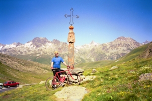 At the top of the Croix de Fer we found hundreds of
people and cars- hikers, hang gliders, bicyclists. I ate
my brioche aux abricots at the summit, delighting in its tart
and sweet flavors. Man, the French can bake! Then we stopped at the
bar at the summit for a sandwich and a drink and waited for Kirk and
Judy. We passed the time watching someone para-sail on the updrafts
from the Maurienne side of the mountain. Kirk arrived after a few
minutes- looking annoyingly cool and fresh- and announced that Judy
was having bike problems and had turned back. He eventually decided
to turn around and go back after her, while Keith and I optimistically
chose to press on to le Galibier. After all, we'd gotten up the Croix
de Fer- an hors categorie climb with fairly minimal difficulty.
How much harder could it be?
At the top of the Croix de Fer we found hundreds of
people and cars- hikers, hang gliders, bicyclists. I ate
my brioche aux abricots at the summit, delighting in its tart
and sweet flavors. Man, the French can bake! Then we stopped at the
bar at the summit for a sandwich and a drink and waited for Kirk and
Judy. We passed the time watching someone para-sail on the updrafts
from the Maurienne side of the mountain. Kirk arrived after a few
minutes- looking annoyingly cool and fresh- and announced that Judy
was having bike problems and had turned back. He eventually decided
to turn around and go back after her, while Keith and I optimistically
chose to press on to le Galibier. After all, we'd gotten up the Croix
de Fer- an hors categorie climb with fairly minimal difficulty.
How much harder could it be?
We left the Croix de Fer and decended through a barren landscape to
St. Sorlin d'Arves. There I gave Keith a couple of pointers about
descending, in return for his pointers about speaking French. The
roads after that were initially perfect for practice. Suddenly I
found Keith was right behind me at all times as we zoomed down a long,
long descent into the Maurienne valley. The descent from Croix de Fer
passes through spectacular valleys and then drops right into
St. Jean-de-Maurienne. It was very hot and we stopped at a small gas
station-convenience-store-deli where we got a snack and some drinks.
I was craving salt and had a bag of potato chips as well. Keith was
having sinus trouble and bought Fisherman's Friends eucalyptus
lozenges. We rode out the only connector road to
St. Michel-de-Maurienne, the N6. We were struggling along at about 15
mph with a tailwind, sweltering in the high humidity and heat of the
valley (the local thermometers read 34 to 36 degrees C), which puzzled
and even alarmed us until we realized that while the road looked flat,
it was actually uphill from St. Jean to St. Michel. We stopped at
a patisserie for more food "for the pocket" and located the
D902 out of town. We were now on La Route des Grandes
Alpes.
As seems to be the case in the French Alps, the climb up the D902
to the summit of the Col de Telegraphe began instantly on leaving
town. There was practically a crease in the road at the bottom of the
climb. The road was in full sun up almost the entire climb, which was
just a switchbacky slog up the hill. The lower slopes seemed much
steeper than the upper ones, but nonetheless the climb seemed to just
go on and on. I was having some trouble with what at first appeared
to be flashers or spots in my field of vision, but which turned out to
be sweat rolling back and forth along the brim of my cap and then
dripping off steadily. It gave me something to watch as I slogged up
the mountain; I was definitely not enjoying this climb. We passed
several older riders whom we had seen on the Croix de Fer as well.
By the top of the Telegraphe I was suffering quite a bit. I got
off and sat in the shade of the large sign in the parking lot across
from the summit's bar, ate a banana and a pave des pommes from
the patisserie in St. Michel. My legs were rubbery and my
hands where shaking. I drained my water bottles and Keith went across
to the bar to refill them. After a rest, we descended into Valloire
where we checked the Meteo at the Office de Tourisme and
then stopped at another patisserie for more food "for the
pocket." At the patisserie there were several young French
military folks standing around, looking very young and fit. At the
intersection in front of the patisserie, the local gendarmes
were randomly stopping drivers and checking credentials. We refilled
water bottles and rode up the street back to the D902. I was feeling
much better although a little apprehensive about the Galibier,
given how hard I had found the Telegraphe.
 From the Valloire side, the Galibier is a long,
long slog of some 25 km. The grade stiffens considerably at the top,
which switchbacks through a garden of tumuli and short grasses and
lichens. It is stark and beautiful and, on a hot day after 60 miles
in the saddle in which one has consumed 16 water bottles but has not
yet had to pee in over 8 hours, it is a merciless soul-crushing brute.
Lord knows what my electrolyte profile looked like by them. Never in
all my years as a cyclist had I ridden myself to a standstill; it
happened today. Galibier won, and I had to get off and walk. I can't
blame it on the mountain, of course. It just is what it is and I was
not prepared to ride over 100 miles, over two 2000 to 2500 meter
passes and a 1500 meter pass, in wiltingly hot conditions. At any
event, I couldn't pedal any further and got off the bike. I walked,
trying to eat the pastry I had bought in St. Michel but being too
dehydrated to get it down. My water bottles had only a couple ounces
of water left in them, which helped. After 100 meters or so I turned
a corner and there saw the Tunnel du Galibier, a bar and Keith
standing in front of the bar, cleaning off his bike. I had been
defeated with about 300 meters left of the climb. I didn't care.
From the Valloire side, the Galibier is a long,
long slog of some 25 km. The grade stiffens considerably at the top,
which switchbacks through a garden of tumuli and short grasses and
lichens. It is stark and beautiful and, on a hot day after 60 miles
in the saddle in which one has consumed 16 water bottles but has not
yet had to pee in over 8 hours, it is a merciless soul-crushing brute.
Lord knows what my electrolyte profile looked like by them. Never in
all my years as a cyclist had I ridden myself to a standstill; it
happened today. Galibier won, and I had to get off and walk. I can't
blame it on the mountain, of course. It just is what it is and I was
not prepared to ride over 100 miles, over two 2000 to 2500 meter
passes and a 1500 meter pass, in wiltingly hot conditions. At any
event, I couldn't pedal any further and got off the bike. I walked,
trying to eat the pastry I had bought in St. Michel but being too
dehydrated to get it down. My water bottles had only a couple ounces
of water left in them, which helped. After 100 meters or so I turned
a corner and there saw the Tunnel du Galibier, a bar and Keith
standing in front of the bar, cleaning off his bike. I had been
defeated with about 300 meters left of the climb. I didn't care.
I went into the bar to get my water bottles filled, only to be told
in apologetic sign language (accompanied by pretty fluent English)
that there was no water on the mountain today. I bought an Orangina
and the proprietress found some water for me from somewhere in the
bar- I didn't ask. Going back outside, I joined Keith and we rode
through the Tunnel du Galibier rather than riding over the summit,
which I couldn't have done. I think Keith was disappointed with that
but he stuck with me. Coming out the south end of the tunnel, we were
confronted with the much-larger-than-I-expected Souvenir Henri
Desgranges. We stopped for photos, while I still felt dull and
lifeless (it shows in the photos). There was another bar a few
hundred meters down the hill, where the same "yes we have no water"
pantomime was repeated. With dry water bottles, we headed down the
hill. 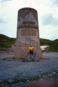
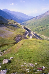
The south side of the Galibier is more arid than the north side.
On the way down, zooming through the switchbacks revived me and I felt
better, although I was apprehensive about having to climb the Col du
Lauteret. As I descended further and further, I got more and more
bummed out. After about 6 km of technical descending (aided by French
drivers pulling over and letting me go by them; little did I know that
Kirk and Judy had passed us driving up the mountain to see what had
become of us), I came to an intersection with several buildings at a
road marked "N91"- the road to the Col du Lauteret and back to
Bourg-d'Oisans. I stood there for a couple of minutes, trying to make
out which way to go to the Col du
Lauteret. Across the street from me was a hotel under
construction and I stared at it before I realized I was looking at
the Hotel des Glaciers. A few seconds later I
remembered that the Hotel Glacier is on top of the Col du
Lauteret and was being reconstructed after suffering a fire several
years ago. We had descended to the top of the pass! I can't
even describe the relief I felt at realizing I was done with climbing
mountains for the day.
Keith and I crossed the N91 to the Hotel's entrance. I took our
water bottles in and was met by a charming, tall middle aged woman. I
asked in my terrible French "Avez-vous l'eau pour notre bidons,
s'il vous plait?" She replied "Oui, oui, oui" and started
to point me out the front door. Changing her mind almost instantly,
she took me in hand to the bar and filled up our bottles herself, as
well as giving me a glass to drink while I waited. She bid
us adieu and bonne chance, and we set out down the N91.
The descent down the Lauteret into the Romanche valley was bumpy with
many signs warning of poor road surfaces (chausse deformee).
We went downhill for kilometer after kilometer, reveling in the speed
and ease although the bumps were getting increasingly uncomfortable
with worsening fatigue. After about 15 minutes of descending I
realized that in a couple of days' time I'd be riding back up this
same road and my heart sank just a bit. Just a little, though,
because it was so nice to be going downhill!
Kirk and Judy had been to the top of Galibier and had come back
down the Lauteret in search of Keith and I. They overtook us at le
Saut de la Pucelle (Maiden's Leap waterfall) and asked if we were
OK. By this time we were feeling much better and ready to carry on to
Bourg-d'Oisans. The road continued down the right side of the river
until crossing at the barrage du Chambon; on the left side it
was in shade, cool and pleasant. We had to stop quite a while for
construction at one tunnel, which was down to one lane for
construction at one end but was beautifully lit and smooth. The road
flattened out for the last few kilometers and it felt odd to actually
be responsible for pedaling the bike rather than coasting. We even
got a sprinkle of rain for a few seconds, the only precipitation we
had in 9 days of riding in the Alps.
 Actually refreshed from the many downhill
kilometers- essentially from the top of the Galibier all the way back
to Bourg-d'Oisans- we were delighted to pull into the gite, 12 1/2
hours after we left. It was the longest ride I'd done in years,
probably the hardest ride I'd ever done, and included the equivalent
of probably a month's worth of climbing back home. Of course, that
also meant the equivalent of a month's worth of descending! All in
all, I didn't feel too bad- just tired. A few liters of water and a
hot shower were just the ticket to revive us, and our wonderful
hostess Mme Pauline had thoughtfully saved dinner for us, which was of
course delicious. We probably almost emptied the pantry by the time
we were done. Filled with dinner and a sense of accomplishment, we
retired to our rooms. Once again in the quiet and crisp Alpine air,
we slept very well indeed!
Actually refreshed from the many downhill
kilometers- essentially from the top of the Galibier all the way back
to Bourg-d'Oisans- we were delighted to pull into the gite, 12 1/2
hours after we left. It was the longest ride I'd done in years,
probably the hardest ride I'd ever done, and included the equivalent
of probably a month's worth of climbing back home. Of course, that
also meant the equivalent of a month's worth of descending! All in
all, I didn't feel too bad- just tired. A few liters of water and a
hot shower were just the ticket to revive us, and our wonderful
hostess Mme Pauline had thoughtfully saved dinner for us, which was of
course delicious. We probably almost emptied the pantry by the time
we were done. Filled with dinner and a sense of accomplishment, we
retired to our rooms. Once again in the quiet and crisp Alpine air,
we slept very well indeed!
106.5 miles (170.4 km) in 9:17:45.
On to Days 4 and 5
